watershed assessment
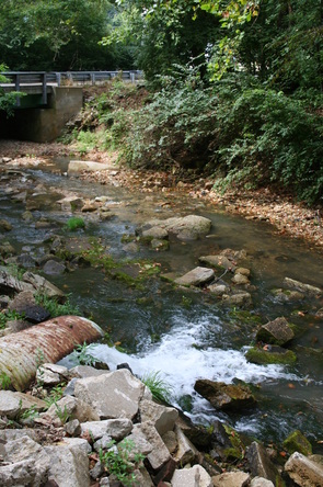
This spring flows under the road through a rusty culvert and discharges to the main channel of the northern branch of the Kiefer Creek Watershed. The pipe is surrounded by chunks of concrete from an old bridge that was demolished but was not removed.
|
All watersheds exhibit a number of key features that are important to consider when assessing watershed ecosystem health and hydrology. To better understand the fundamental elements and underlying structure of the Kiefer Creek Watershed, we have studied the following:
|
These features interact in numerous complex ways and in the Kiefer Creek Watershed they have seen significant modification due to human activity and development. Therefore, the watershed must be considered in many dimensions to identify solutions to water quality issues and environmental degradation. Information gathered in the study of the major elements of the watershed is used to identify priority areas for restoration and preservation, develop milestones for reforestation and biodiversity efforts, and to provide the watershed community and stakeholders with in depth information about the nature of the watershed.
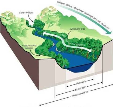
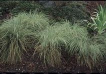
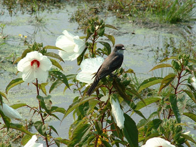
Healthy riparian areas support a range of functions, such as nutrient cycling, water filtration, erosion prevention, slowing and infiltrating stormwater runoff, and providing habitat corridors for wildlife.
These functions give riparian areas unique values relative to the surrounding landscape. Riparian buffers are most effective at improving water quality when they include a native grass or herbaceous filter strip along with deep rooted trees and shrubs along the stream.
|
www.uvm.edu
|
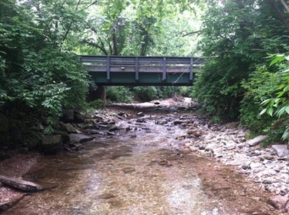
Riparian buffers surround Kiefer Creek at the
New Ballwin Road Bridge |
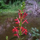
Because riparian zones are the low areas in an ecosystem landscape, it is common to find groundwater nearer to the surface and readily available for plants. In addition the fine, textured sediments in flood plains and Riparian Zones have the capacity to hold large amounts of water. These two conditions are ideal for the promotion of healthy and diverse plant communities
Riparian Zones are essential to freshwater ecosystems in Missouri, especially in an urbanized area such as the Kiefer Creek Watershed. Defining the Riparian Zone of a water body is not an exact science, in general the bigger the buffer the more beneficial ecological services will be provided. Many organizations have identified a good rule of thumb to follow such as 50 or 100 feet, avoiding complex variables such as slope or soils. In the Kiefer Creek Watershed we have combined a general and specific approach to defining the riparian zone, with our efforts focused on identifying areas where it can be improved. We used the best available data on stream flows and impoundments in the watershed to create buffer zone offsets at 10, 20, 30, 40 and 50 meters. These buffers were then used to clip out areas where there are no trees or other vegetation over 1 meter in height. This process has identified areas in the watershed where limited natural resource restoration can provide the greatest benefit to water quality. We have also used the alluvium to define the floodplain in the watershed, which frequently overlaps and includes our initial buffer zones, but is further informed by the topography of the watershed. This area is a good area to focus on plant |
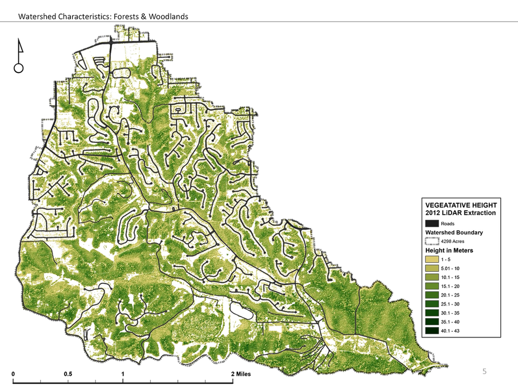
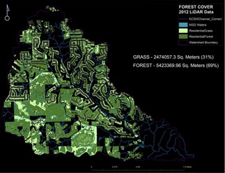
Wetland forests, and Riparian forests in particular, are critical to watershed health. Forests in the watershed prevent erosion, act as a bio-filter, provide habitat, and absorb rainfall. It is therefore important to support the succession of native tree species, which provide these services with far greater efficiency than invasive plants. In the Meramec Basin, forests are dominated by oak species, with black-scarlet oak and white oak are the dominant upland forest types. Stand size-classes should be roughly 45% saw timber, 30% pole timber, and 18-25% seedling and sapling timber (MDC).
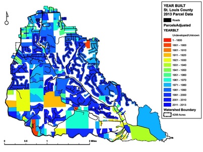
land use
Large, contiguous tracts of forest are best able to support species in the watershed. However, over the past century, much of the watershed has been broken up into small parcels, developed, or turned into cropland, leaving it ill suited to providing habitat to native species. Estimates from the NRCS (1995) classify the Meramec Basin area as: 48% forest, 24% pasture, 15.7% water, minor and other land-use categories, 6.5% urban development, 4.5% cropland, and 1.3% rural transportation. Forests in this area are controlled by a variety of owners, each of whom plays a major role in forest succession patterns. In the Kiefer Creek Watershed the breakdown is little different. Kiefer has a much higher amount of urban development than most of the Meramec Basin, but it has less than most of the other Lower Meramec Sub-sheds.
|
We can also look

|
|
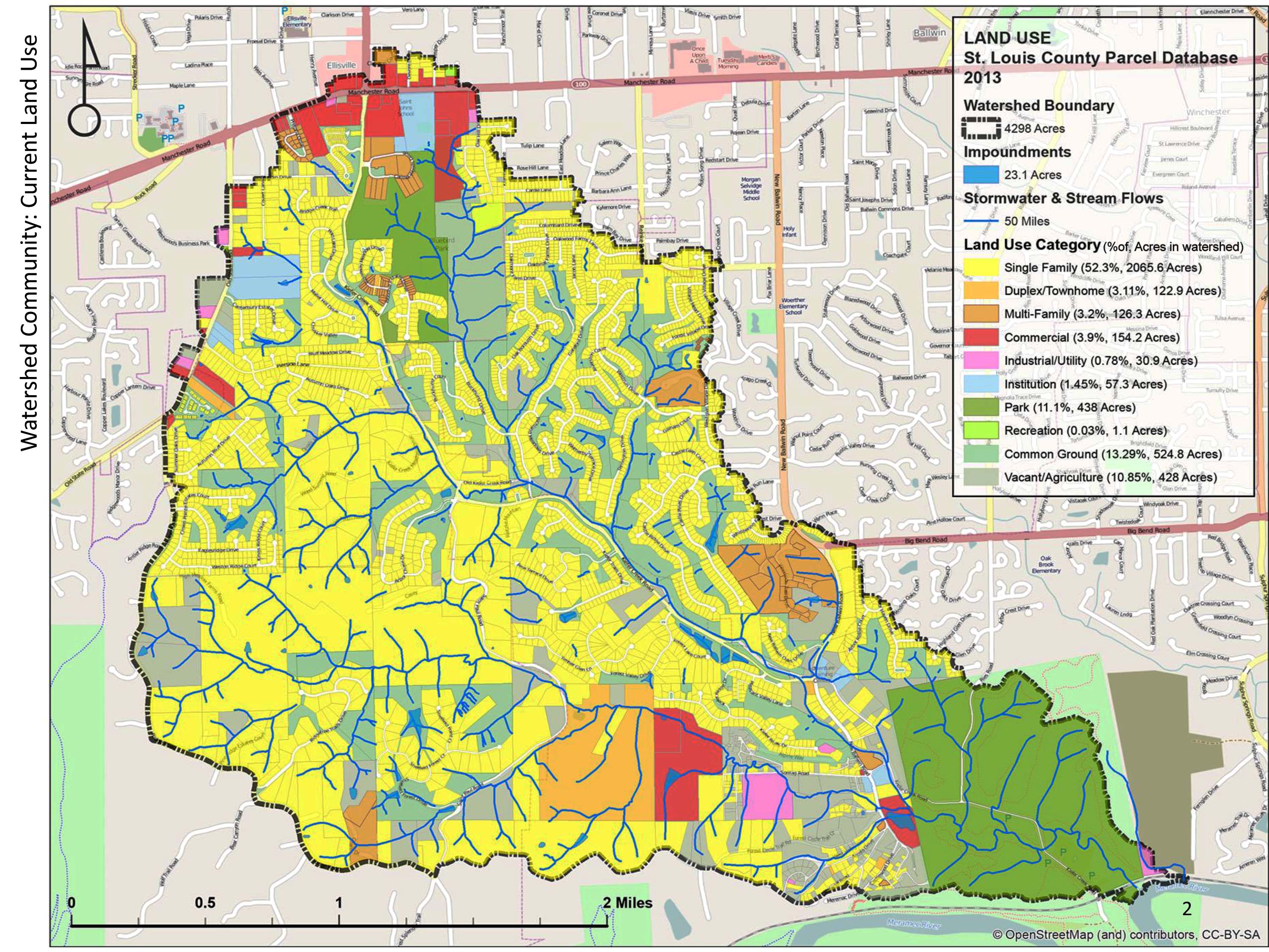
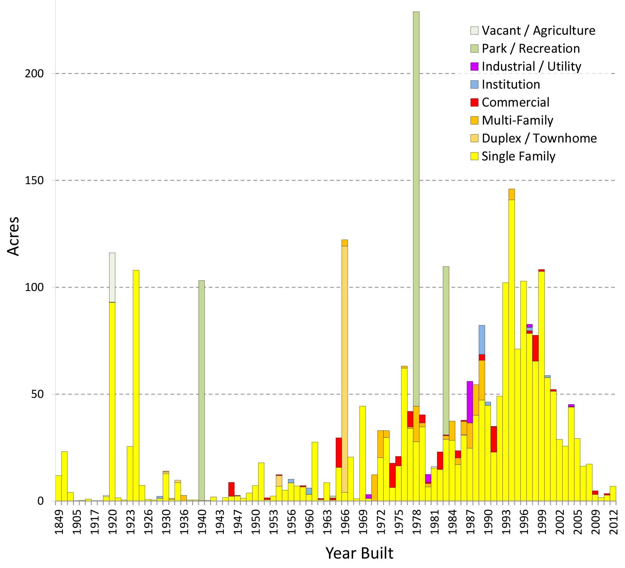
In the Kiefer Creek Watershed we see that just over half of the watershed is held in single family residential use, however when we look closer it is apparent that some single family parcels are quite large and include significant amounts of green space. On the opposite end of the spectrum there is some medium and high density residential in the watershed that offers almost a fourth of the total housing units in the watershed, yet takes up only 6.3% of the watershed.
|
The breakdown of forest and turf in residential areas of the watershed
|
|
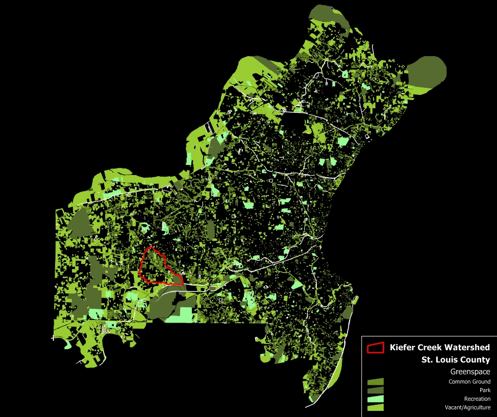
Here we can take a look at just the green space uses in St. Louis County (left) and get a closer look at the Kiefer Creek greenspace uses (below). There are four types of greenspace identified on these maps:
Common Ground: This is land typically owned by the adjacent subdivision. In the Kiefer Watershe 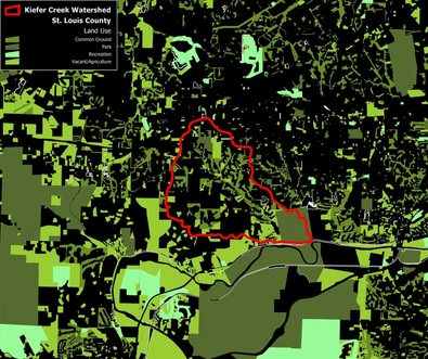
|
WHY IS BIODIVERSITY IMPORTANT?
The Kiefer Creek watershed has a diverse and rich natural heritage, with species and ecological communities of regional, state, and global significance. The natural systems are the scenery and living fabric that provides the Kiefer Creek watershed with a regional identity, and creates a sense of place for its residents. Healthy, natural systems are in essence a "green infrastructure" that supplies services to support life as we know it through the purification of drinking water, control of floodwaters, replenishment of aquifers, pollination of flora, and much, much more. They also provide opportunities for hunting, fishing, outdoor recreation, and environmental education and research. All of these services and benefits to the community cost less than the artificial or built alternatives, contribute to local economies, and are widely recognized as important assets.
|
|

Watershed planning provides an ideal opportunity to consider conservation of our biological resources. The plants, animals, and habitats - or biodiversity - of the Kiefer Creek watershed are a significant part of the character of our region, the natural infrastructure, the economy, and contribute directly to the quality and quantity of water available to residents living in the region.
The term "biodiversity" is used to describe all the components of nature that are needed to sustain life. While people often associate the term biodiversity with threatened and endangered species, it actually encompasses much more. Biodiversity refers to all living things, both rare and common, the complex relationships between them, species diversity, and variability in natural communities, ecosystems, and landscapes. All of these parts and processes comprise the web of life that contributes to healthy ecosystems.
The term "biodiversity" is used to describe all the components of nature that are needed to sustain life. While people often associate the term biodiversity with threatened and endangered species, it actually encompasses much more. Biodiversity refers to all living things, both rare and common, the complex relationships between them, species diversity, and variability in natural communities, ecosystems, and landscapes. All of these parts and processes comprise the web of life that contributes to healthy ecosystems.

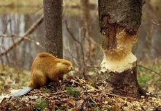
Beavers have a strong presence in the watershed. Beaver dams have led to the formation of a number of wetlands along the course of Kiefer Creek
in just the past few years that we have been studying the watershed.
in just the past few years that we have been studying the watershed.
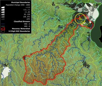
The Kiefer Creek Watershed is a 6.7 square mile tributary watershed of the Meramec River Basin. It sits on the cusp of the intensive suburban development typical to western St. Louis County and the rural ozark hills typical of the Meramec River, with both landscapes playing a significant role in the current condition of the watershed.
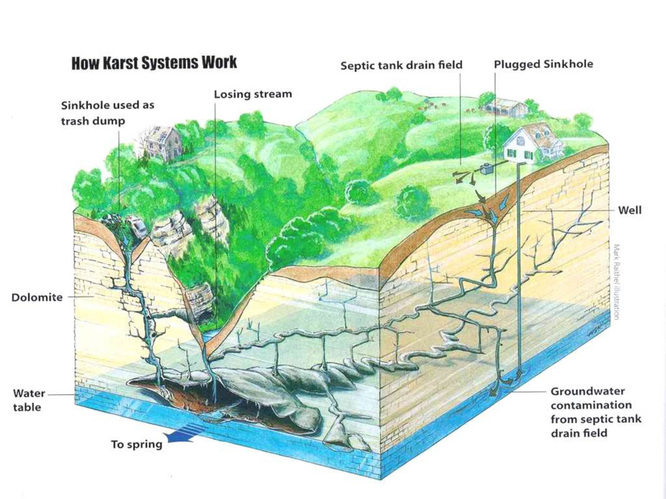
KARST TOPOGRAPHY
The Kiefer Creek watershed contains more than a dozen springs, including two of the largest springs in St. Louis County: Kiefer Spring and Sontag Spring. These springs are part of the watershed's Karst landscape: a topography marked by a high water table, springs, and caves.
The Kiefer Creek watershed contains more than a dozen springs, including two of the largest springs in St. Louis County: Kiefer Spring and Sontag Spring. These springs are part of the watershed's Karst landscape: a topography marked by a high water table, springs, and caves.

The emergence of Kiefer Spring along Kiefer Creek Road. The stone enclosure that gathers the flow of the spring and sends it under Kiefer Creek Road may have been constructed around the 1920's or 30's.
The St. Louis area has historically had an abundance of Karst systems, most of which have been degraded over time by increased development and impermeable surfaces. In an area with mostly paved surfaces, rainwater does not have a chance to be absorbed into the groundwater. Instead the streams flash flood when it rains, sending all the water directly downstream. |
Kiefer Creek has both springs, and areas of losing stream where the flow is absorbed into the groundwater faster than it is replenished. These two conditions mean that the water quality of Kiefer Creek is dependent on the quality of the groundwater in addition to the quality of the runoff and drainage that reaches the stream bed. This makes Kiefer Creek highly susceptible to bacteria leaked from faulty septic systems in the area. Furthermore, groundwater does not follow the topographical boundaries that delineate watersheds, and it is likely that the spring water feeding Kiefer Creek originated from an area much wider than the watershed, carrying with it the accumulated contamination.
|
Kiefer Creek has kept its Karst system healthy because it has seen less development than the surrounding watersheds. New development usually means an increase in paved surfaces and a decrease in permeable surfaces. Compared to surrounding areas the Kiefer Creek watershed has much more permeable surfaces, so it has been able to maintain its springs.

This website and other efforts related to the Kiefer Creek Restoration Project are partially funded by the Environmental Protection Agency Region 7 through the Missouri Department of Natural Resources, under Section 319 of the Clean Water Act. MoDNR Subgrant G13-NPS-01.