Kiefer creek history
Pre-development
|
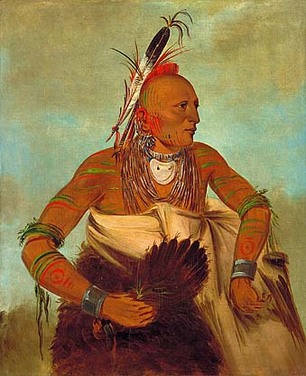
Prior to European arrival in the 1770’s, the Kiefer Creek Watershed was likely home to the people of the Osage and Illinois Tribes. Before the disturbances of development altered the landscape, the Kiefer Creek watershed was likely covered primarily by forests with patchy glades on the rocky balds atop bluffs carved by the Meramec.
There would have been a healthy population of beavers, whose dam building would have produced wetlands interspersed along the stream channel. These wetlands would have been teeming with life; many species would have flourished in spring fed wetlands, cold and rich with oxygen. They likely supported an amazing diversity of amphibians, shellfish, mussels, turtles, fish, crayfish and other macro-invertebrates. These would have been the foundation of a predatory branch of the food chain that would have topped out with mountain lions and bears. The bison, deer, elk and other herbivores in the area during this time likely thrived on a diet of diverse native trees, shrubs, grasses, wildflowers, and aquatic plants. |
|
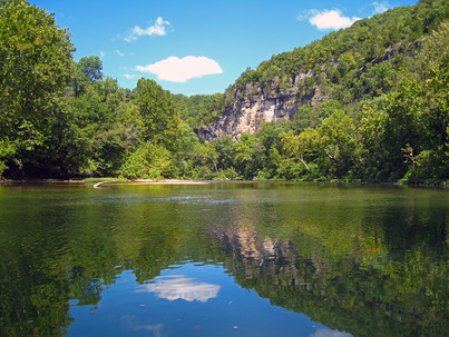
Bluffs along the Meramec River
|
The creek was, and still is, fed by numerous perennial and intermittent springs and the stream bed was frequently punctuated by deep holes that likely served as reproductive areas for aquatic macro-invertebrates, fish and shellfish. Without the massive influxes of stormwater from impervious surfaces, the stream channel would have been much narrower than it is today and the banks intact. There would have been less gravel transported out to the Meramec than there is today. Kiefer Creek would have been your typical flourishing spring-fed tributary to the Meramec.
|
Castlewood Village: A Vacation Destination
|
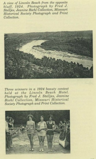
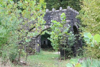
In the second half of the 1800’s, the Lower Meramec became a popular destination for fishing trips, with visitors coming all the way from St. Louis. As a result of the gravel mining operations along the Meramec, large deposits of sand formed beaches along the Lower Meramec. These beaches became popular destinations for weekend excursions around the turn of the 20th century. The Kiefer Creek Watershed became a hub of these recreational activities, providing easy access to Sherman Beach. The popularity of the Kiefer Creek Watershed was thanks in part to the railroad and Castlewood Train Station that St. Louisians would ride to the area. Between 1900 and 1930, resorts, river outfitters, restaurants, hotels and even speakeasies were built to cater to the visiting crowds. The Lone Wolf Club, formally located on the Wildlife Rescue Center property, was a Speakeasy and Tavern built during the 1930's. Crowds to the area began to diminish, as did the business of The Lone Wolf Club in the 1990's. The ‘ruins’ of the resort can still be seen on the grounds of the Wildlife Rescue Center.
In the early 20th century, clubs and vacation homes were developed along the Meramec River. The Missouri Pacific Railroad brought city dwellers to cool down in the river, and Castlewood Village kept them entertained with hotels, clubs, bathhouses and more. Much of the development occurred over the limestone bluffs north of the Meramec and the railroad tracks. The seclusion of these bluffs attracted visitors; during prohibition there was a robust drinking and gambling culture away from the eyes of authorities.
|
|
|
DECLINE
In the 1950s, the cost of cars and air conditioning decreased. Clubs and hotels in the Castlewood area began to shut down as fewer people took the train to Castlewood to escape the city’s heat. Family homes replaced the vacation culture, but the area remained relatively secluded. |
Conservation efforts
|
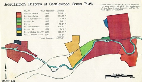
In the 1970s, as development in the area increased, the expanding St. Louis suburbs began to encroach upon Kiefer Creek watershed. Unlike its neighbors, however, the Kiefer Creek watershed largely retained its natural landscape and avoided the extensive development that blanketed neighboring Fishpot Creek Wateshed. In order to ensure that this beautiful area was not destroyed by rapidly encroaching suburbs, the Open Space Council of St. Louis helped the state acquire some of the land in 1974 to create Castlewood State Park.
|
|
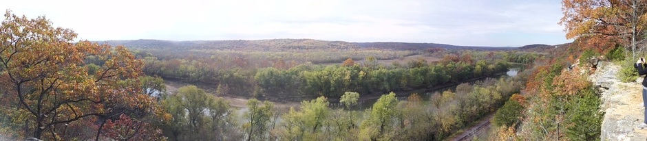
The amazing view looking out across vast acreage of conservation lands in the Meramec River Basin from the bluffs that form the southern edge of the Kiefer Creek Watershed in Castlewood State Park
SUPERFUND DIOXIN CLEANUP
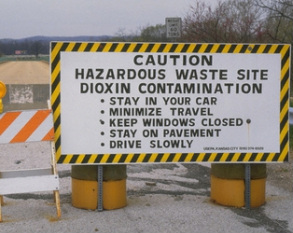
Times Beach, a small town about 20 miles south of St. Louis along the Meramec, is the site of a well known Superfund Cleanup site. The town was evacuated in the early 1980’s due to dioxins found in waste oil sprayed on dirt and gravel roads and parking lots to control dust. The Superfund Cleanup that followed necessitated the construction of an incinerator to burn the toxic waste. The areas within the watershed that were included in the Superfund site have remained largely undeveloped since the cleanup. In a way, the tragic chemical spill may have protected some of the most fragile riparian and forested areas from the impacts of development.
Suburban Development
|
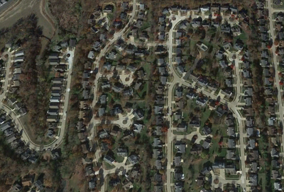
By 1990, watersheds adjacent to the Kiefer Creek watershed neighboring watersheds were quite developed, while the Kiefer Creek watershed remained largely untouched. The watershed retained a large amount of its tree cover and natural spaces. This has helped Kiefer Creek to retain its natural beauty and clear, flowing water.
Since 1990, there has been a fair amount of expansion into the watershed, primarily in the northern part of the watershed. The southeast section of the watershed still looks much like it did in 1990. |

This website and other efforts related to the Kiefer Creek Restoration Project are partially funded by the Environmental Protection Agency Region 7 through the Missouri Department of Natural Resources, under Section 319 of the Clean Water Act. MoDNR Subgrant G13-NPS-01.